
The story below is a preview from our May/June 2018 issue. For the full story Subscribe today, view our FREE interactive digital edition or download our FREE iOS app!
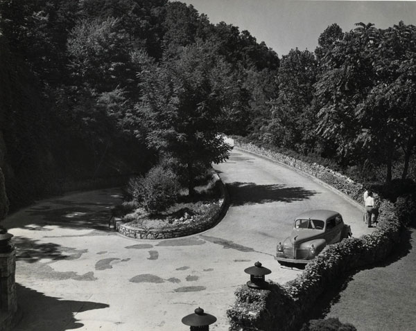
The Loop Road on Mill Mountain, so named for its loop, is nearly unchanged fromits 1891 beginnings.

Location
Mill Mountain
Features
Mill Mountain’s Prospect Road, commonly called the Loop Road or Old Toll Road, still has the same basic design when it originated as a graded carriage road in 1891. Today, the road is part of the Roanoke Valley’s greenway system within Mill Mountain Park.
History
A strong desire by Roanoke’s business leaders to take advantage of the vistas and cooler summer temperatures on the summit of Mill Mountain prompted its development for recreational use. While the mountain had been hiked to enjoy the panoramic views, the desire for an inn and observatory necessitated the building of a road.
In 1891, Roanoke Gas and Water Company acquired the western slope of Mill Mountain from the Roanoke Land & Improvement Company in its primary effort to control the Crystal Spring reservoir. The company, however, clearly knew the benefit of owning the mountain as an economic and recreational asset.
Thus, the Gas and Water Company hired local builder F.D. Booth to develop a $10,000 hotel and $2,000 observatory at the summit along with a winding road with a 10% slope up the northwestern face of the mountain. The hotel would become Rockledge Inn and the carriage trail Prospect Road.
Rockledge Hotel (later Inn) formally opened on May 3, 1892, with a grand dinner. The guest list included local dignitaries and executives with the Norfolk & Western Railway, some of whom traveled from Philadelphia for the occasion. Carriages were positioned at the railway station to transport guests between the train depot and the hotel.
Efforts to make Mill Mountain a recreational draw proved difficult. Rockledge, while roomy and boasting of the grandest views of the Roanoke Valley, was primitive by the standards of the day especially when compared to the Hotel Roanoke. Further, the carriage ride to the top of the mountain along Booth’s winding dirt road took between two and three hours. Many hiked the mountain in less time than it took to ride a carriage. Rockledge Inn closed only two years after it opened.
Downturns in the economy coupled with other failed ventures to attract persons to Mill Mountain’s summit, such as the short-lived Mill Mountain Incline, forced Roanoke Gas and Water Company to sell much of the slope of Mill Mountain. The gas company sold the land to the Mill Mountain Corporation, an entity owned by brothers John and William Henritze. The Henritzes’ vision was for upscale residential development at the foot of the mountain and resort-like amenities at the top. To this end, the brothers set about building a $90,000 scenic toll road along the same route as Booth’s old carriage road.
The toll road opened on August 30, 1924, with a toll rate of 25 cents per car. At the time it was a marvel. The road was reported to be the longest continuous 6% concrete road in the world and had the defining feature of a “loop-the-loop” where the road passed over itself.
William Henritze built his magnificent residence, called Rockledge, along the loop road. The road was 18 feet wide with expanded widths of 30 to 40 feet at sharp curves. By the 1930s, some 20,000 cars per year were taking advantage of the scenic passage up Mill Mountain. Ironically, the toll road brought about the demise of the Mill Mountain Incline that closed in 1929.
What Happened?
The Depression brought hardship to the Henritze brothers such that their vision of a resort atop Mill Mountain never materialized. Facing bankruptcy, the Henritzes were unable to sell Mill Mountain, and creditors forced foreclosure.
The mountain was sold to investors associated with Washington & Lee University. Offered by the investors to the City of Roanoke without success, the mountain was bought by Mr. and Mrs. J.B. Fishburn in 1941 and eventually donated by them to the city for park purposes. During this time and in the succeeding decades, the toll road was largely neglected.
In 1969, long-delayed focus was given to the toll road with an emphasis on repairs for vehicular use. In 1971, however, the J.B. Fishburn Parkway was completed that provided better access to the mountain from both Roanoke City and the Blue Ridge Parkway, replacing the toll road as a primary route to the summit.
A few years later, Roanoke planners forged a new vision for the toll road to be a pedestrian-only route. This dovetailed better with emerging desires to preserve and protect the slope of the mountain as a natural asset.
Significance
Today, Prospect Road is a portion of the Mill Mountain Greenway following the same roadbed laid out almost a century ago. A journey to the summit along the road leads to the discovery of remarkably intact remnants of the original toll road, including the Toll House constructed in 1924 with its stone archway over the road. “The Loop” is at the mid-point, and the switchback design has given Prospect Road its more commonly-used name of Loop Road. Some of the original stone retaining walls and drainage structures still exist reflective of early 20th Century masonry.
While the Henritze brothers’ vision of a resort on Mill Mountain did not happen, one could suggest their early effort to make the mountain accessible via the toll road ultimately kept interest and attention focused on Roanoke’s most visible natural asset. Further, their road is used by many today to enjoy Mill Mountain in ways they may have never envisioned.
… for more from our May/June 2018 issue, Subscribe today, view our FREE interactive digital edition or download our FREE iOS app!